
Listen to this article
Estimated 3 minutes
The audio version of this article is generated by AI-based technology. Mispronunciations can occur. We are working with our partners to continually review and improve the results.
The storm of September 2026 will be one that Cape Bretoners never forget.
The slow-moving weather system first brought heavy rounds of rain from the south on Friday and Friday night and battered most of the Island, but especially Richmond County.
Rainfall rates on Friday night were devastatingly high with 20 to 30 millimetres per hour recorded.
Infrastructure just can’t keep up with that much rainfall in such a short period of time.
The weather station in Sampsonville recorded 150 millimetres in just six hours between midnight and 6 a.m. AT Saturday.
Eskasoni recorded 71 millimetres in just three hours during part of that window.
 Rainfall totals in Cape Breton from Friday morning through Monday morning. (Ryan Snoddon/CBC)
The storm then wrapped more moisture in from the east and northeast, which brought more heavy rounds of rain throughout the day on Saturday, especially across Victoria and Cape Breton counties, and metro Sydney.
With additional rainfall Sunday night and into Monday, localized storm totals have now climbed above 250 and even 300 millimetres for parts of Victoria County.
What did the weather models predict?
Overall, forecast models predicted this storm and the heavy rainfall.
By Friday morning, many forecast models were predicting widespread totals of 80 to 150 millimetres across the island, with some showing localized pockets of more than 200 millimetres, especially over Victoria County.
That said, it’s extremely challenging for the models to predict significant localized rainfall of this magnitude.
Nothing predicted the devastating 20 to 30 millimetres per hour that fell Friday night in the Bras d’Or Lake region though. There’s just too much going on in the atmosphere to project exact amounts and the exact locations where it will fall.
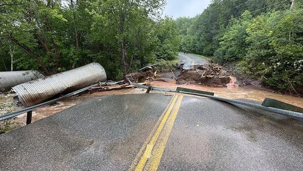
 This was a common sight in Cape Breton over the weekend. (Paul Poirier/CBC)
While overall amounts ended up higher and the pockets of 200 millimetres ended up more widespread, generally forecast models did a fairly good job signalling the storm.
This storm will now be added to the growing list of recent severe weather events over the past decade alone, including:
While it’s tough to link any single storm to climate change, the frequency and severity of severe storms hitting Cape Breton and the province over the past decade has become increasingly noticeable.
The growing list of significant weather events point toward a clear trend of more intense, high-impact storms.
MORE TOP STORIES