![]()
Listen to this article
Estimated 4 minutes
The audio version of this article is generated by AI-based technology. Mispronunciations can occur. We are working with our partners to continually review and improve the results.
Red tornado warnings were issued for several London-area communities Thursday afternoon and evening as a severe thunderstorm made its way across southwestern Ontario, bringing torrential downpours and strong winds.
As of 7:50 p.m., all tornado warnings had been lifted for the London and Chatham-Kent areas, however thunderstorms continued to cross the region.
One warning, issued just after 7 p.m. for Chatham-Kent, Rondeau Park, and western Elgin County, had said the “tornado location” was over Moraviantown, moving eastward at 40 km/h. The warning for Elgin County was the second to be issued for the area in less than a hour.
A tornado has not been confirmed by Environment Canada or by Western University’s Northern Tornadoes Project.
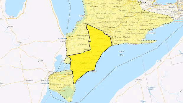
 Environment Canada weather advisories and warnings as of 8 p.m. on June 25, 2026. Solid yellow areas are severe thunderstorm warnings, while translucent yellow areas are severe thunderstorm watches. (Environment Canada)
Previous tornado warnings, issued around 6:40 p.m. for parts of western Elgin County, including Rodney and Shedden, and around 6 p.m. for western Middlesex County, including Strathroy, were lifted before 7 p.m.
Those warnings had said a “tornado location” was over Glencoe, moving east at 40 km/h, and then over John E. Pearce Provincial Park, moving east at 25 km/h.
“I was noticing a weird parting in the clouds, so I watched it for a minute and then my heart kind of stopped because I realized that it was actually coming down,” said Glencoe-area resident Amanda Vanderkuyl.
“All of a sudden, I could literally see the wall of water coming out. You can hear it over the trees from the house, so it was kind of cool and a little bit scary to watch,” she said. “Then, it blew in like a freight train.”
Vanderkuyl said she estimates the weather event was a total of 10 minutes. Other than a few plants blowing over, she said there was no damage to her property.
Still, Vanderkuyl said this storm stood out from recent weather events in the region.
“We get side-swiped with the storms a lot, but it doesn’t typically come straight over,” she said. “I felt like I could’ve touched it.”
Tornado warnings had been in place in the late afternoon in Sarnia and eastern Lambton County, including Lambton Shores, Grand Bend, Pinery Provincial Park, and Watford. The warnings were lifted around 6 p.m.
Most of southwestern Ontario remained under a severe thunderstorm watch as of 8 p.m., with some areas under severe thunderstorm warnings.
If threatening weather does approach, take cover in a basement or interior room, the weather statement advised. Anyone outside, it adds, should protect themselves from flying debris and hail, and secure any loose objects.
Local utility outages were also possible, Environment Canada said, with wind gusts up to 90 km/h and the possibility of toonie-size hail.
Earlier in the day, Environment Canada meteorologist Peter Kimbell said the severity of the storm would depend, in part, on how much sun the region received over the course of the afternoon.
“It’s kind of a double-edged sword,” he said. “We want the sun, but the more sunshine we get on day like today, it will increase the temperatures and increase the instability and cause some thunderstorm activity.”
Tornado risk initially considered low
When CBC News spoke with Kimbell, he said the risk of a tornado was very low, explaining that while some of the atmospheric conditions are favourable, it was not a high risk.
“It’s not like in some situations, we have the (wind) shears being very high, and that would increase the likelihood of a tornado. That’s not the case today.”