
Listen to this article
Estimated 4 minutes
The audio version of this article is generated by AI-based technology. Mispronunciations can occur. We are working with our partners to continually review and improve the results.
Shelter-in-place advisories remain in place in B.C.’s Pemberton Valley and parts of the District of Squamish as flooding threatens local properties and roads.
Residents are told to stay where they are, unless they are covered by an evacuation order. Those under order are told to leave immediately.
The order areas include parts of Líl̓wat Nation and part of the village of Pemberton.
Líl̓wat Nation expanded an evacuation order for its community Thursday morning. It said flooding was occurring along the Green River, which is experiencing “exceptionally high flows.”
“The Lillooet River is forecast to continue rising for several more hours. The Birkenhead is flowing near record levels,” the order reads.
The Líl̓wat Nation has EXPANDED the Evacuation Order from Kwetsa7 along the Lillooet River corridor to Lillooet Lake due to flooding. Flood waters are a threat to life & safety. Go to Úll̓us Community Complex. If water blocks your route, do not attempt to cross. Move to a safe location on higher ground & call for assistance. For immediate danger or rescue call 911. More info: https://t.co/zGyQznHOE9 #BCFlood #BC
The nation says sections of Lillooet Lake Road had about six inches to one foot of water flowing over it.
People are urged not to walk or drive through floodwater.
The nation has a muster point and reception centre open at Úll̓us Community Complex.
WATCH | Flood warnings remain in place:
Rivers, streams running high in Sea-to-Sky region after days of heavy rain
In Pemberton, an evacuation order covers the Pemberton Regional Airport, the B.C. Wildfire Service base, golf course facilities, an animal shelter and a small number of residential properties.
A reception centre is open at the Pemberton and District Community Centre.
The entire village is under evacuation alert, as well as properties within the Electoral Area C portion of the Pemberton Valley.
The valley is also covered by a shelter-in-place advisory.
The Squamish-Lillooet Regional District (SLRD) says sections of Pemberton Meadows Road and Highway 99 are impassable.

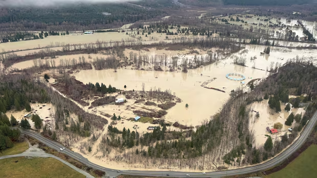
Flooding affecting the Líl̓wat Nation near Pemberton as of 1:30 p.m. on Thursday, Nov. 12, 2026. (David Ward)
While it is still too early to estimate the scale of damage, the Líl̓wat Nation believes dozens of homes have been affected.
“We’re all very tired,” said Líl̓wat Nation political Chief Dean Nelson. “I’m responding to the emergency and looking out for the safety of our people.”
Canada Post issued a red delivery service alert due to the flooding impacting Pemberton. It said in a statement that all mail and parcels destined for the village will be held at a Canada Post facility until postal services can resume.
In the District of Squamish, a shelter-in-place advisory covers the Paradise Valley, Sunwolf Lodge and Cheekye Ranch area due to flooding downstream of the Cheakamus Dam (Daisy Lake).

Squamish Valley Road was closed at the Pilchuck Bailey Bridge due to flooding concerns on Thursday. (Troy Charles/CBC)
The district said Paradise Valley Road is closed at the Paradise Valley Bailey Bridge and Squamish Valley Road is closed at the Pilchuck Bailey Bridge.
“There is some impact to property,” Squamish Mayor Sean Easton said. “We don’t have a clear description of what that looks like at this time. The stay in place order is still active as we’re waiting for river levels to recede.”
The district says river levels are expected to peak today and begin to drop as rainfall from the storm works its way through the river system.

Floodwaters are seen from a helicopter along the Lillooet River on Thursday. (Submitted by David Ward)
More rain on the weekend
Easton said the district is used to big storms and heavy rainfall, and is preparing for another weather system on the weekend.
“We’re trying to respond in this moment, but then also trying to look at it and make sure that we’re ready for the next storm moving through,” he said. “It’s unclear what that storm looks like, as far as amounts at this time.”
He said the district’s emergency operations centre is monitoring the situation.

Squamish Mayor Sean Easton said the Sea-to-Sky community is bracing for more storms on the weekend. (Mike Zimmer/CBC)
Pemberton Valley and parts of the South Coast are under a flood warning, with the River Forecast Centre saying river levels there “have been rising rapidly since late Tuesday night” and are expected to continue to rise into Thursday.
“There’s still quite a bit of uncertainty in the weather forecast,” said David Campbell, head of the River Forecast Centre.
“That’s something that we’re going to continue to monitor closely over the next couple days here as we get into the weekend, and whether there’s any kind of additional flood hazard through that period.”
The centre has also issued flood warnings for the Kingcome River and Vancouver Island.
High streamflow advisories are in place for southern Vancouver Island, the Fraser Valley, Fraser Canyon and Chilcotin.
Environment Canada has rainfall warnings in effect for east, inland and west Vancouver Island, as well as parts of the Sunshine Coast.