Doug MacLeod could see the danger bearing down on him.
In early August, the forestry contractor was marking trails for heavy equipment to plow fire breaks on the mountainside above Faulder, a community near Summerland in British Columbia’s southern Okanagan valley.
He had tied only a single piece of flagging tape when he saw the Bald Range wildfire roaring through the forests toward him.
“This is death coming over the mountain,” Mr. MacLeod remembers thinking. He abandoned flagging and started pounding on residents’ doors, urging them to flee.
He watched as fire ripped across the valley and cut off Fish Lake Road, the only viable route out of the area. Knowing he and dozens of residents were now trapped, Mr. MacLeod leaned on his training and decades of wildfire experience to give those around him the best possible chance to survive.
He picked a grassy meadow as far from the tree line as he could get. If the fire went over them, he told people, they would lie face down, hands over their heads, pressing their lips into small air pockets scraped into the dirt. It would be a last-ditch effort to avoid death. They could survive, he thought, but there would be injuries.
Luckily, a wind shift in the nick of time allowed BC Wildfire Service helicopters to land and start what became a huge air-lift rescue effort.
It could have been much worse, Mr. MacLeod said. “This was so close to being a couple of hundred people [dead].”


Tap to view the before and after
Satellite imagery shows Faulder, B.C., in October, 2024 and on Sept. 18, nearly a month after the Bald Range wildfire burned through more than 25,000 hectares of forest.
Planet Labs/Airbus/Google Earth

The northwest flank of the Bald Range wildfire burns near Summerland, B.C.
Courtesy of B.C. Wildfire Service via The Canadian Press

A structure damaged by the Bald Range wildfire along Garnet Valley Road in Summerland, B.C., on Aug. 24.
Aaron Hemens/The Globe and Mail
The fire’s behaviour was unlike anything Mr. MacLeod had ever seen. After nearly 50 years of working in forests, he understood the growing hazard, driven by years-long drought and decades of unchecked forest ingrowth, before the Bald Range fire exploded.
But the scale of the danger is largely invisible to most Canadians until it’s too late. Though some wildfire hazard mapping is publicly available in B.C., there is a patchwork of incomplete data. And in the rest of the country, such information is virtually non-existent.
“I think people got to be aware of what’s around them, and communities have to be aware of what’s around them,” Mr. MacLeod said.
Experts warn that a failure by governments to make detailed hazard mapping publicly available has left towns and cities across the country more vulnerable to the threat of extreme wildfires. Without the information, communities continue to build new housing in high-hazard areas even as critical mitigation efforts are frequently delayed.
In light of these concerns, a Senate committee is calling for a new national hazard mapping strategy – and public data similar to what is already available in the United States.
But some critics worry governments may not be up to the complicated task. And even when there is an earnest effort to improve public data, officials can face significant backlash as property owners fear financial consequences. Fire officials in Oregon were forced to largely abandon detailed hazard mapping after trying to make better information publicly available.
There is no denying the trendline: Climate change is driving wildfires that are faster and hotter than ever before, and disasters like the Bald Range fire are becoming more common. Are Canadians ready to open their eyes to the risk?
Devestated neighbourhoods in the aftermath of the Almeda fire in Medford, Ore., in 2020.
Adrees Latif/Reuters
Hoping to avoid such staggering losses in the future, state legislators also decided to tie each property’s hazard rating to legislated requirements for the property owners. New construction would have to meet a stricter, more fire-resistant building code. And landowners were handed retroactive requirements to do mitigation work like removing or pruning back trees on at-risk properties, efforts proven to help improve a home’s chances of surviving a wildfire.
Despite being backed up by sound science, the effort blew up in officials’ faces as livid homeowners accused the state of driving up insurance rates and driving down property values.
“We got death threats. We had to cancel meetings. Our state police said, ‘This [threat] is too credible. You can’t go to these particular communities,’” Mr. Dunn said.
Under pressure, the state quickly withdrew the new requirements for homeowners. The maps themselves were temporarily taken down and eventually replaced with simplified versions.
“What happened was a monumental public backlash, unlike anything we’ve seen in recent policy here,” Mr. Dunn said. “The public response was so entrenched in misinformation, misunderstandings that it was just not surmountable, and so the legislature pulled away.”
Most frustratingly for Mr. Dunn, the claim that the maps were driving up insurance rates or causing homeowners to lose coverage altogether was untrue.
Insurance companies in both the Canada and the U.S. have their own sophisticated risk modelling, Mr. Dunn said. They already know better than most homeowners what risks a particular home faces.
Liam McGuinty, vice-president of federal affairs for the Insurance Bureau of Canada, agreed the insurance industry has become sophisticated at gathering data to price wildfire risk.
“The quality of risk modelling and mapping has improved fairly significantly over the past several years, and so insurers know a lot.”
But as useful as that modelling is, insurance companies don’t make it public because it’s proprietary and expensive to produce. That’s another reason for better public hazard maps, experts say: They could help put homeowners on a more even footing with their insurance providers by giving them a neutral source of information about their properties.
Mr. McGuinty told the Senate committee his industry supports the call for better mapping. He said significant federal and provincial data exists that isn’t shared outside of government agencies.
Structures damaged by the Bald Range wildfire in Summerland, B.C., on Aug. 24.
Aaron Hemens/The Globe and Mail
There are two key questions, he said: whether provincial and municipal governments actually use the maps to guide development and hazard reduction work, and whether homeowners are empowered to understands the risks they face.
“In my view, the answer to both is no,” Mr. McGuinty said.
Nationally, he said, “we’re set to build 200,000 homes in high-risk wildfire areas in the next five years, unless policies change. We’re building right now in high-risk wildfire areas.”
Mr. McGuinty said he worries wildfire hazard mapping could suffer a fate similar to that of the federal government’s Flood Risk Finder tool, part of a $228-million effort by Ottawa to help Canadians understand the risks to their properties from floods.
That online map operates like a hypothetical fire hazard map could: Homeowners can punch in their addresses and, based on regional data, quickly get an estimated flood risk rating on a four-point scale from “low” to “extreme.”
The tool launched in April. The problem, Mr. McGuinty said, is that it’s currently useless because not a single province or territory has chosen to opt in. Visitors to the website are met only with a “coming soon” notice, and the search function greyed out.
The B.C. government said that, like with wildfire hazard mapping, it supports the flood risk finder tool in theory. “We have questions for the federal government about limitations of the tool and engagement with local governments and First Nations,” B.C.’s Ministry of Environment and Climate Readiness said in a statement to The Globe. Other provincial governments have given similar reasons for not signing on.
“The tools exist. The mapping exists. It’s ready to go. Consumers would benefit from it,” Mr. McGuinty said. “Are those maps perfect? No, but let’s not let perfect be the enemy of the good here.”

How you can make your home less vulnerable to wildfires
As the risk of impacts from wildland fire is increasing, FireSmart Canada has developed guidelines for home construction, maintenance, landscaping and evacuation planning to minimize risks when wildland fires occur.
BEST PRACTICES FOR PLANNING, DESIGN AND CONSTRUCTION
Non-combustible or ignition-resistant
siding material
Non-combustible gutters and downspouts
Deck/porch with non-combustible or fire-rated materials
Non-combustible materials such as gravel in the 1.5-metre area adjacent to the property
and wooden fence
Multi-pane tempered glass windows
Fire-rated roofing materials
Metal vents with three-millimetre metal screening
Garage and exterior doors fitted with weather stripping to prevent ember entry
Deciduous plants instead of conifers
THE HOME IGNITION ZONE
The HIZ is the area within 30 metres of your home, divided into three priority zones. By addressing fire risks from the Immediate zone outward, you can reduce your home’s vulnerability to wildland fire.
Immediate zone
0 to 1.5 metres
Clear vegetation and combustible material down to mineral soil and cover with non-combustible materials like gravel, brick or concrete
Avoid planting woody shrubs or trees or dense vegetation.
Intermediate zone
1.5 to 10 metres
Use fire-resistant, preferably deciduous, plants and non-combustible landscaping materials.
Keep the area free of woody debris, mulch and other combustible materials.
Intermediate zone
1.5 to 10 metres
Space tree crowns at least three metres apart and prune branches up to two metres from the ground.
Regularly remove fallen branches, dry grass and needles to reduce surface fuels.
MURAT YÜKSELIR / THE GLOBE AND MAIL,
SOURCE: FIRESMART CANADA

How you can make your home
less vulnerable to wildfires
As the risk of impacts from wildland fire is increasing, FireSmart Canada has developed guidelines for home construction, maintenance, landscaping and evacuation planning to minimize risks when wildland fires occur.
BEST PRACTICES FOR PLANNING, DESIGN AND CONSTRUCTION
Non-combustible or ignition-resistant
siding material
Non-combustible gutters and downspouts
Deck/porch with non-combustible or fire-rated materials
Non-combustible materials such as gravel in the 1.5-metre area adjacent to the property
and wooden fence
Multi-pane tempered glass windows
Fire-rated roofing materials
Metal vents with three-millimetre metal screening
Garage and exterior doors fitted with weather stripping to prevent ember entry
Deciduous plants instead of conifers
THE HOME IGNITION ZONE
The HIZ is the area within 30 metres of your home, divided into three priority zones. By addressing fire risks from the Immediate zone outward, you can reduce your home’s vulnerability to wildland fire.
Immediate zone
0 to 1.5 metres
Clear vegetation and combustible material down to mineral soil and cover with non-combustible materials like gravel, brick or concrete
Avoid planting woody shrubs or trees or dense vegetation.
Intermediate zone
1.5 to 10 metres
Use fire-resistant, preferably deciduous, plants and non-combustible landscaping materials.
Keep the area free of woody debris, mulch and other combustible materials.
Intermediate zone
1.5 to 10 metres
Space tree crowns at least three metres apart and prune branches up to two metres from the ground.
Regularly remove fallen branches, dry grass and needles to reduce surface fuels.
MURAT YÜKSELIR / THE GLOBE AND MAIL,
SOURCE: FIRESMART CANADA

How you can make your home less vulnerable to wildfires
As the risk of impacts from wildland fire is increasing, FireSmart Canada has developed guidelines for home construction, maintenance, landscaping and evacuation planning to minimize risks when wildland fires occur.
BEST PRACTICES FOR PLANNING, DESIGN AND CONSTRUCTION
Fire-rated roofing materials
Non-combustible or ignition-resistant
siding material
Multi-pane tempered glass windows
Non-combustible gutters and downspouts
Deck/porch with non-combustible or fire-rated materials
Metal vents with three-millimetre metal screening
Deciduous plants instead of conifers
Garage and exterior doors fitted with weather stripping to prevent ember entry
Non-combustible materials such as gravel in the 1.5-metre area adjacent to the property
and wooden fence
THE HOME IGNITION ZONE
The HIZ is the area within 30 metres of your home, divided into three priority zones. By addressing fire risks from the Immediate zone outward, you can reduce your home’s vulnerability to wildland fire.
Firewood and auxiliary structures at least 10 metres from the property
Immediate zone
0 to 1.5 metres
Intermediate zone
1.5 to 10 metres
Extended zone
10 to 30 metres
Clear vegetation and combustible material down to mineral soil and cover with non-combustible materials like gravel, brick or concrete
Avoid planting woody shrubs or trees or dense vegetation.
Use fire-resistant, preferably deciduous, plants and non-combustible landscaping materials.
Keep the area free of woody debris, mulch and other combustible materials.
Space tree crowns at least three metres apart and prune branches up to two metres from the ground.
Regularly remove fallen branches, dry grass and needles to reduce surface fuels.
MURAT YÜKSELIR / THE GLOBE AND MAIL, SOURCE: FIRESMART CANADA
Before the Bald Range fire, local government knew about growing wildfire risks in the area – even though provincial data was incomplete and a federal map was not available.
The Regional District of Okanagan Similkameen, which is responsible for the rural areas around Summerland, including Faulder, said the district relied in part on data provided by private landowners who’d had their own hazard assessments completed.
The district worked to address the risks through the FireSmart B.C. program, which helps homeowners with tailored strategies like removing flammable plants, pruning or removing coniferous trees, and installing fire-resistant roofing and siding material.
It tends not to focus on the risks growing in forests beyond the immediate area around a house or structure, which is where public hazard mapping could play a bigger role. But when the wildfire reached the edges of Summerland itself, the efforts of the local community made a significant difference.
In Summerland, the neighbourhood of Deer Ridge used a FireSmart risk assessment to highlight areas that needed tree pruning and other vegetation clean up. After the fire, local fire chief Rob Robinson said that work helped prevent flying embers from landing farther into town, giving firefighters a critical advantage that helped save homes.
Funding ran out in February, and while the B.C. government added an extra $15-million to cover FireSmart projects in 2027, it has not yet said what the future of the program will be.
Given the history of wildfires in B.C.’s southern interior, many Summerland and Faulder residents are better informed about their wildfire risk than most Canadians. Even so, some didn’t fully comprehend the scale of the hazard the way Mr. MacLeod, the forestry contractor, had.
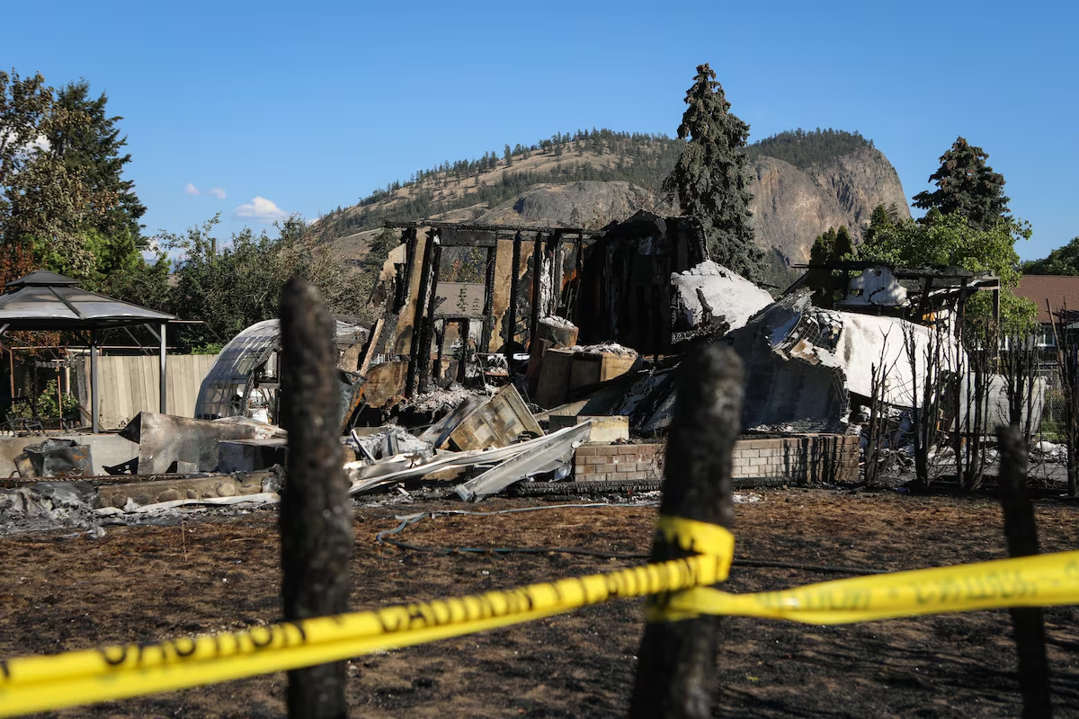
Brandon Bishop and his wife Alora lost their home to the wildfire last month. Their property was one of 73 that were levelled when the fire rolled into Faulder.
Mr. Bishop said the rural community was accustomed to life in the bush, and had a general sense that the forests were becoming very dense. Local officials had begun talking more about the need for FireSmart projects.
But he said he did not fully appreciate just how dense and loaded with fuel the forest and mountains around his home really were.
“To be honest, I knew it was hot and dry. But it didn’t seem any worse than usual. I mean, fire danger in our area is always high at that time of year,” Mr. Bishop said.
If public hazard maps were available, he thinks that could have motivated the community to press harder for protective measures, and get involved themselves.
“I think that people would probably get out in the forest a little bit more and be willing to help with that. Especially if it means saving their community in the long run,” he said.